- Where and when
- Frequencies
- Visual Map
- Calculated ve2dbe.com line of sight Signal Map
- Post Contest report
2025 ARRL June VHF Contest!
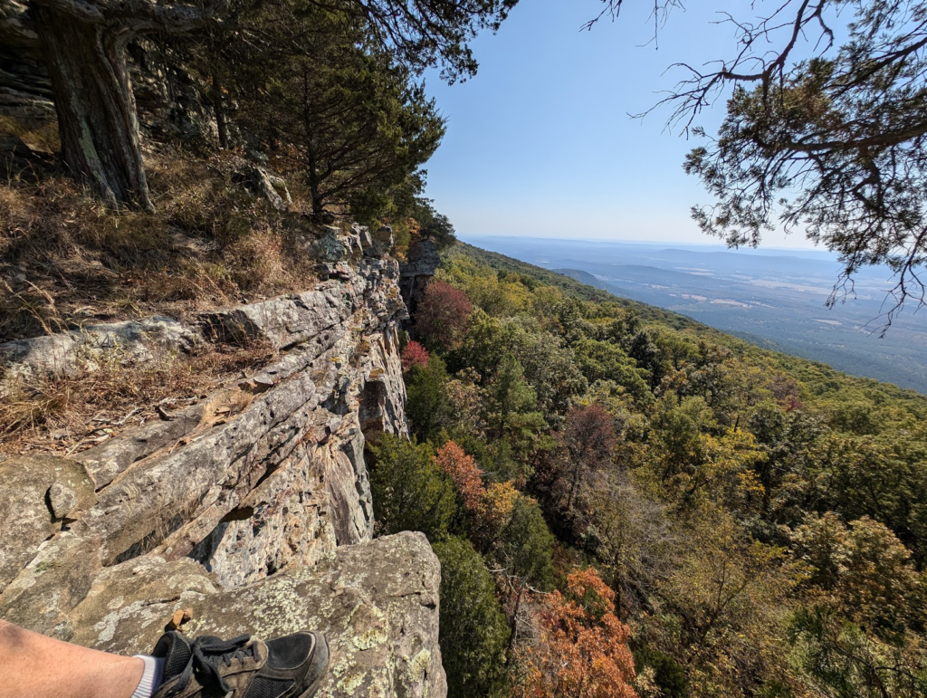
The view to the Northwest in October when Lisa and I had a chance to visit the park!
Begin: Saturday June 14 at 1 PM Central
End: Sunday June 15 at 10 PM Central
My call will be N5ZY/R for Rover
ARRL VHF Contest Rules: arrl.org/june-vhf
Also check for my friends in OKROVER.INFO
13-June 2025: I’m at Mount Magazine testing 6m on the North face and working the East coast with ease! The only problem is that I cannot move around with even the 6m loop on top due to low hanging limbs. So I may not be switching sides due to the time involved with remove/stow, scoot, unstow/attach.

I have gain antennas and verticals but of course it’s one or the other..
Just a bit crazy in here but don’t worry I’m thinking of seeing a doctor about that.
Mount Magazine stands as the crown of Arkansas, offering not only stunning vistas but also a strategic perch for VHF contesting. My plan for the 2025 ARRL June VHF Contest is to take full advantage of this unique location. Weather permitting, I’ll be operating from both the north and south faces of the mountain, aiming to maximize contacts and provide new grid squares to as many operators as possible.
Operating from Mount Magazine presents its own set of challenges. The summit itself isn’t accessible by vehicle, so I’ll be moving between different overlooks along the roadway, setting up wherever the terrain and propagation look most promising. This means a lot of setup and teardown, but the reward is the chance to work stations in all directions and enjoy some of the best scenery in the state.
My primary goal is to beat my personal best score, and if I happen to break into the section’s top 10, that would be the icing on the cake. I’ll also be experimenting with a 3-element 6m beam—though swapping antennas means staying put a bit longer, it might just pay off when the band opens.
Of course, rover life is never predictable. From dodging tree limbs that threaten the antennas to fielding questions from curious onlookers, every stop brings its own surprises. Sometimes, explaining the “offensive-looking” rover vehicle takes more time than making contacts! But that’s all part of the adventure.
After wrapping up on Mount Magazine Sunday morning, I’ll hit the road, chasing new grids north and west before heading home. The schedule below is more of a wish list than a guarantee—rover plans always seem to change on the fly. No matter what, I’m looking forward to a weekend of radio, road miles, and Arkansas mountain air
Grid Squares – Where and when
| Local Time | Grid | Lat, Lon | Elevation (Ft) | Note | Gmap Link |
|---|---|---|---|---|---|
| SATURDAY 1PM until band dies | |||||
| 1,3,5PM | EM35 | 35.17419, -93.64629 | 2570 | North face of Mount Magazine AR | Google Map |
| 2,4,6PM | EM35 | 35.16378, -93.64182 | 2540 | South face of Mount Magazine AR | Google Map |
| SUNDAY 8AM to 10PM | |||||
| 9 – 9:30 AM | EM26 | 35.48581, -94.22585 | 430 | Citizens Bank, 124 Highway 71 N, Alma, AR | Google Map |
| 9:30- 9:45AM | EM26 | 35.49264, -94.24261 | 458 | Alma Intermediate School Field & Track, 1428 Collum Ln W, Alma, AR 72921 | Google Map |
| 10:30-10:45 AM | EM26 | 36.05842, -94.20301 | 1495 | S Centennial Park Ln, Fayetteville, AR 72704 | Google Map |
| 11:00-11:45 AM | Springdale Supercenter [ChargePoint] 4870 Elm Springs Rd, Springdale, AR 72762 | ||||
| 11:45- 12PM | EM26 | 36.23008, -94.15453 | 1520 | 5264 Callahan Mountain Rd, Springdale, AR 72762-8235 | Google Map |
| 12:20- 12:35 | EM26 | 36.37672405051125, -94.11471923706493 | 1335 | Rogers Muni Airport, 139 N Airport Loop, Rogers, AR 72756 | Google Map |
| 12:40- 1 PM | EM36 | 36.44053659189072, -93.972538690441 | 1660 | Water tower 14560 Blueberry Ln, Garfield, AR 72732 | Google Map |
| 1:10- 1:45 PM | EM26 | 36.44099721289904, -94.03179508338542 | 1388 | Pea Ridge Nat. Military Park, 15930 National Park Dr, Garfield, AR 72732 (Telegraph Rd, Garfield) | Google Map |
| 2:15- 3PM | Springdale Supercenter [ChargePoint] 4870 Elm Springs Rd, Springdale, AR 72762 | ||||
| 4:30- 5:20 PM | Hard Rock Casino 777 W Cherokee St, Catoosa [Francis Energy] | ||||
| 5:45- 6:10 PM | EM15 | 35.98641544392852, -96.01012986069085 | 700 | Comfort Inn, 12119 N Casper, Sapulpa, OK 74037-4423 | Google Map |
| 6:20- 6:45 PM | EM16 | 36.01003599086504, -96.04655841374262 | 800 | Creek Turnkpike Overlook 10699 S 49th West Ave, Sapulpa, OK 74066 | Google Map |
| 7PM – 10 PM | EM26 | 36.07072358651628, -95.99360026170268 | 880 | Turkey Mountain Upper Trailhead 6463 S Elwood Ave, Tulsa, OK 74132 | Google Map |
| Contest over! | |||||
The contest does not end until 10 PM local time Sunday. I will try to always monitor 146.52 FM but when I’m moving I will have to switch to a whip antenna.
APRS Position Beacon
I will use APRSdroid to beacon my live position.
You can see where I am using https://aprs.fi/ and searching for my callsign N5ZY.
Frequencies
For this contest we are allowed to use everything above 6m and the National Simplex Frequency may be used if not busy however for 222 and 902 I’m using transverters from 28 Mhz so my band is limited to 1.7MHz (28.0 to 29.7 MHz).
| Band | WSJT-FT8 (USB) | Call Freq (USB) | QSO Freq (USB) | FM SIMPLEX | FM SIMPLEX 2 | FM SIMPLEX 3 |
|---|---|---|---|---|---|---|
| 6 M | 50.313 | 50.125 | 50.145 | 52.525 | ||
| 2 M | 144.174 | 144.2 | 144.220 | 146.52 | 146.49 | 146.55 |
| 1.25 M | 222.174 | 222.1 | 223.5 | |||
| 70 cm | 432.174 | 432.1 | 446.0 | |||
| 33 cm | 902.174 ? | 902.1 | 902.125 | |||
| 23 cm | 1296.174 | 1296.1 | 1294.5 |
Antennas
| Bands | Antenna |
|---|---|
| Verticals | |
| 2 M | Whip while driving |
| 2/70/23 | Comet Base Vertical CMA-GP-95 while parked only and while the rotor is NOT in use! 6 dBi @ 146MHz, 8.6 dBi @ 446, 12.8 dBi 1.2 GHz |
| 1.25 M | Comet CA-SUPER22 while parked only 6.6 dB @ 222 MHz |
| 33 CM | Comet KP-20 while parked only 9.2 dB @ 902 MHz |
| Horizontals | |
| 6 M | Par Electronics Stressed Moxon, (50.3 Mhz) or M2 Antennas 6M-3SS beam or Par Electronics 6M Omniangle (OA-50) |
| 2 M | M2 Antennas 2M7X (144-148MHz) 7ele 12.3 dBi |
| 1.25 M | M2 Antennas 222-10EZ (222-226 MHz) 10 ele 14.1 dBi |
| 70 CM | M2 Antennas 440-11X (420-450 MHz) 11 ele 13.4 dBi |
| 33 CM | M2 Antennas 917HD (900-930MHz) 17 ele 17 dBi |
| 23 CM | M2 Antennas 23CM35 (1250-1300MHz) 35 ele 20.94 dBi |
Radios
| Radio | Desc/Use |
|---|---|
| IC9700 | 2m, 70cm and 23 cm USB and FM |
| IC7610 | 6m |
| IC7300 | To use with transverters |
| Q5 Signal L33-28hp50 | Converts 10 M to 33 cm |
| Q5 Signal L222-28hp100 | Converts 10 M to 1.25 M |
| Anytone | VHF Mobile |
Visual Map
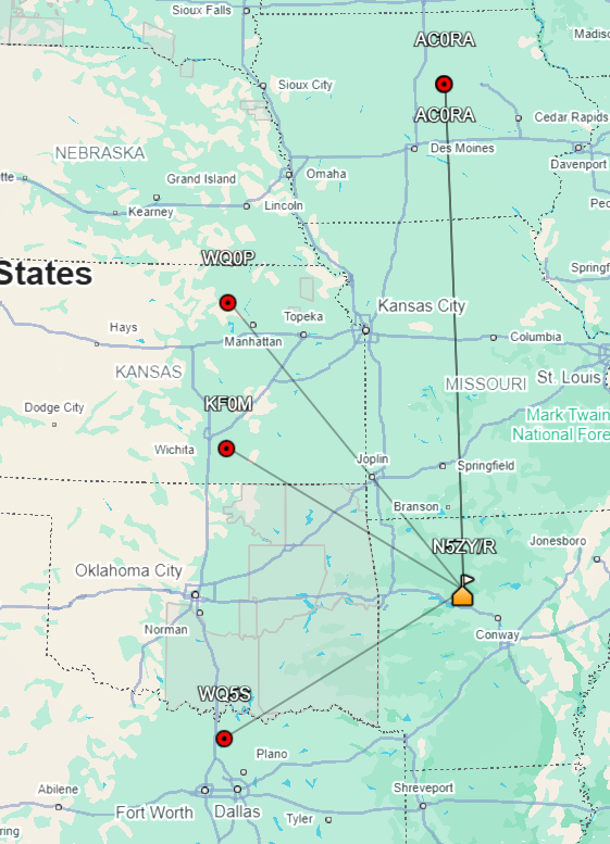
I’m visual.. so here is a map created using https://www.egloff.eu/qralocator/ I’ve added number to represent the order and local where I intend to be on the air. Saturday I will overnight at Mount Magazine so I will be on the air until I’m not making any more contacts, weather permitting! Sunday will be “CQ and scoot”, with a focus on being on the move to activate grids.
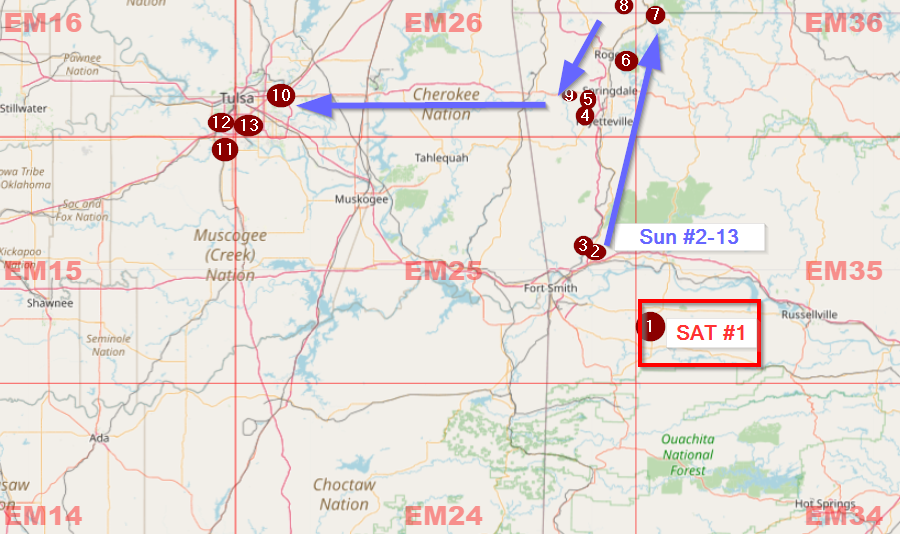
Zoomed out map of the grid corners in Arkansas
Mastery of none!
As you can see from my ARRL VHF Contest Rankings below I’m a newcomer to VHF contesting and rovering. It’s a fun challenge though! I hope this June I can drastically increase my QSO count and multipliers (raw scores published July 1: I did a decent job for a lone bison roaming around!)
| Yr | Mo | Category | Div | Nat Rank/All Cat | Div Rank/ALL Cat Me/Total | Div Rank/Rovers Me/Total | Score | QSOs | Mults | Comment |
|---|---|---|---|---|---|---|---|---|---|---|
| 2022 | Sep | SngOpLP | WGDiv (OK) | 9/25 | n/a | 513 | 28 | 19 | ||
| 2023 | Jan | ClascRovr | WGDiv (OK) | 23/47 | 2/2 | 399 | 17 | 19 | ||
| 2023 | Jun | LimtdRovr | WGDiv (OK) | 411/1588 | 51/100+ | 3/3 | 15228 | 157 | 94 | |
| 2023 | Sep | ClascRovr | WGDiv (OK) | 174/686 | 7/25 | 1/4 | 4182 | 67 | 51 | |
| 2024 | Jun | LimtdRovr | WGDiv (OK) | 154/1133 | 14/72 | 4/7 | 15566 | 180 | 86 | |
| 2024 | Sep | LimtdRovr | WGDiv (OK) | 129/636 | 6/41 | 2/3 | 4922 | 89 | 46 | |
| 2025 | Jan | ClascRovr | WGDiv (OK) | 205/764 | 11/40 | 1/1 | 2366 | 72 | 26 | Brrr!! Artic Blast! |
| 2025 | Jun | ClascRovr | DeltaDiv (AR) | 131/1257 | 6/33 | 3/3 | 35,462 | 233 | 149 | Good test |
| 2025 | Aug 222 and Up | Rover | Area 8 | 4/5 (raw) | 2/2 (raw) | 7,148 (raw) | Retreated Sunday 4AM from Hail storm | |||
| 2025 | Sep | ClascRovr | WGDiv (OK) | 35/540 (raw) | 35/540, 3/32 (raw) | 1/2 (raw) | 29,562 (raw) | 191 | 78 | Missed last grid due to LiFePO4 depletion |
| 2026 | Jan | ClascRovr | WGDiv (OK) | 3,690 (raw) | 71 | 41 |
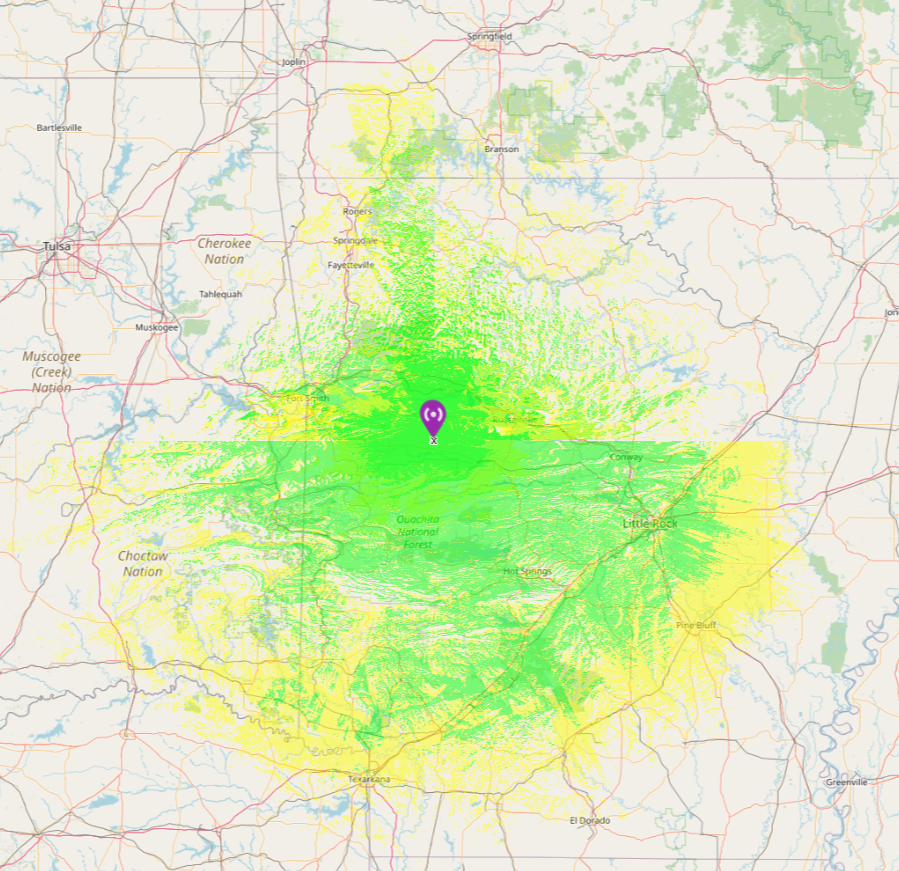
Calculated ve2dbe.com LOS Signal Map
The coverage map below is calculated from the north side and the south side of Mount Magazine using 146 MHz to a 6dBi omni at 100 watts. This map shows the reliability of a site-to-site communication WITHOUT atmospheric enhancement.
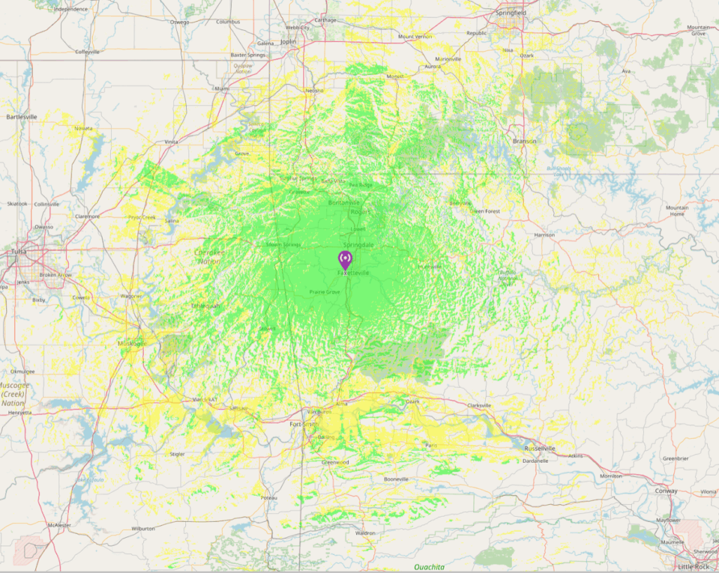
This map is the same criteria but from EM26-Centennial Park, Fayetteville
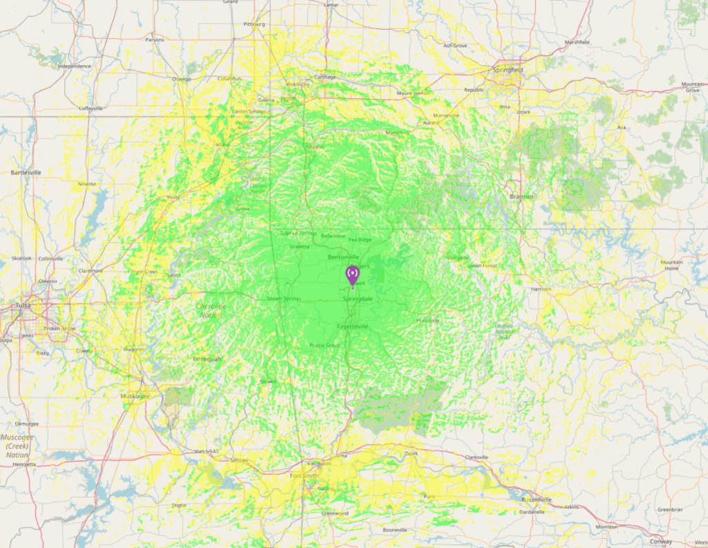
This map shows the calculation from EM26-Callahan Mountain Springdale AR

Skipping up to my last point it looks like I can reach to several metro areas from Little Rock to Springfield to Tulsa!
Post contest summary

676.67 Miles logged on the Kia for this /R trip.
Another VHF contest is in the books, and this year I managed to more than double my previous best score! Maybe it was the Topo map obsession, or perhaps it was just sheer luck that my car didn’t completely give up the ghost when the dashboard lit up like a Christmas tree a few days before the event. (Rule #1: Be resilient—unlike my antenna elements after an argument with a tree limb.)
This was my first rodeo with a portable 6m 3-element beam, and that thing worked! I also packed along transverters for 222 and 902 MHz, but let’s be honest—they mostly just enjoyed the scenic ride and provided me with that soothing sound of static. Between 6m being busier than a swap meet and the weather radar & lightning strike detector demanding my constant attention, I barely had time to blink, let alone sleep or chase those elusive higher bands. I’m sure I missed out on a bunch of opportunities, but hey, I still managed to snag some 2m contacts at a whopping 1,000 miles! Who needs sleep when you have ionospheric magic and a dash of stubbornness?
This contest is the perfect excuse to geek out over maps, plan routes, and dream up wild new radio projects. Every year, it pushes me to learn more, build more, and maybe—just maybe—dodge more thunderstorms while roving from grid to grid. There’s something uniquely satisfying about squeezing into a cockpit full of radio gear, dodging tree limbs, and pretending you’re not just a little bit crazy (don’t worry I’m considering meeting with a therapist.)
My goals for next year? Keep improving, keep moving forward, keep learning, keep mentoring Technician class license holders (encourage them to try VFO mode), and most importantly—keep having fun and exploring new places. After all, if you’re not having fun, you’re doing it wrong.
Finally, a huge thank you to the organizers and log checkers who work tirelessly to make this contest possible. You’re the real MVPs—even if you do make us wait for those results! A huge thank you to everyone in the logbook as well!
| Band | QSOs | Mults |
|---|---|---|
| 6 | 205 | 117 |
| 2 | 38 | 26 |
| 222 | 5 | 4 |
| 432 | 1 | 1 |
| 902 | 1 | 1 |
| 1296 | 1 | 1 |
| Total | 251 | 150 |
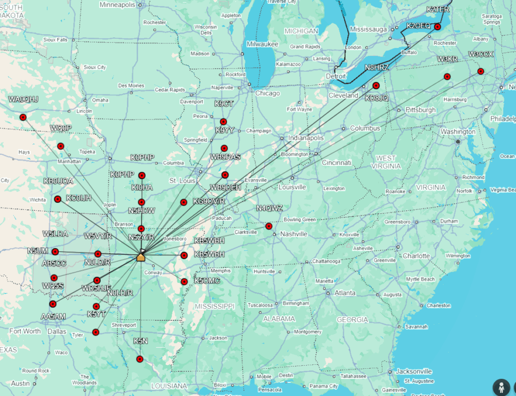
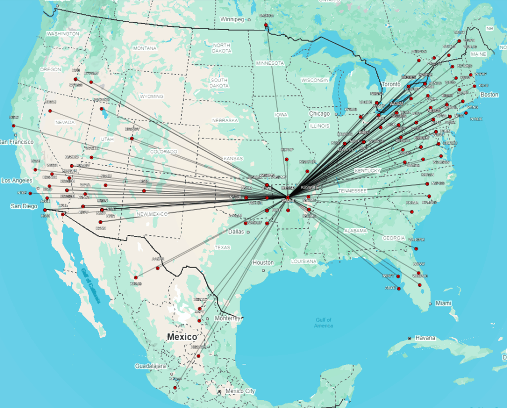
2m contacts from EM35!
The maps below were created using https://www.levinecentral.com/adif2map/
I imported my ADI file then using Levin Centrals site I converted to KML and imported to Google Earth.
Note that for my position and the position of the other stations the app is picking the grid square center not the exact positions.
M2 Antennas 2M7X (144-148MHz) 7ele 12.3 dBi used in EM35 on 2m
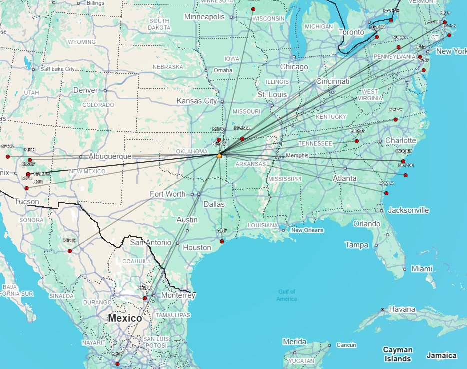
1.25 m contacts from EM35
M2 Antennas 222-10EZ (222-226 MHz), 10 ele 14.1 dBi used in EM35 on 1.25m
6m contacts from EM35
M2 Antennas 6M-3SS used in EM35 on 6m
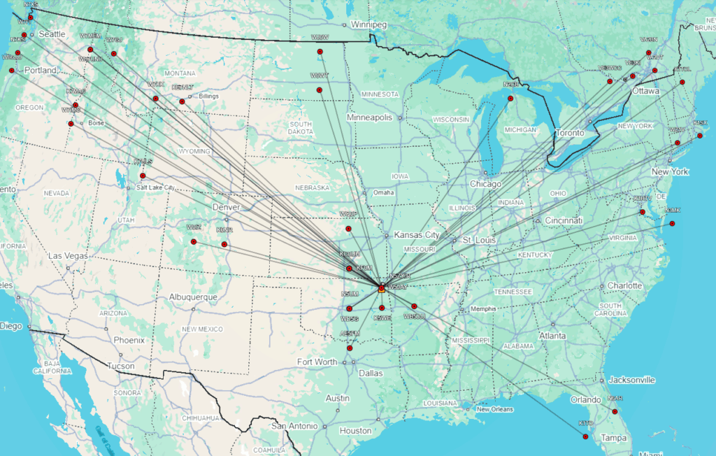
6m contacts from EM25
Par Electronics 6M Omniangle (OA-50) used in EM25 on 6m
6m contacts from EM26
Par Electronics 6M Omniangle (OA-50) used in EM26 on 6m
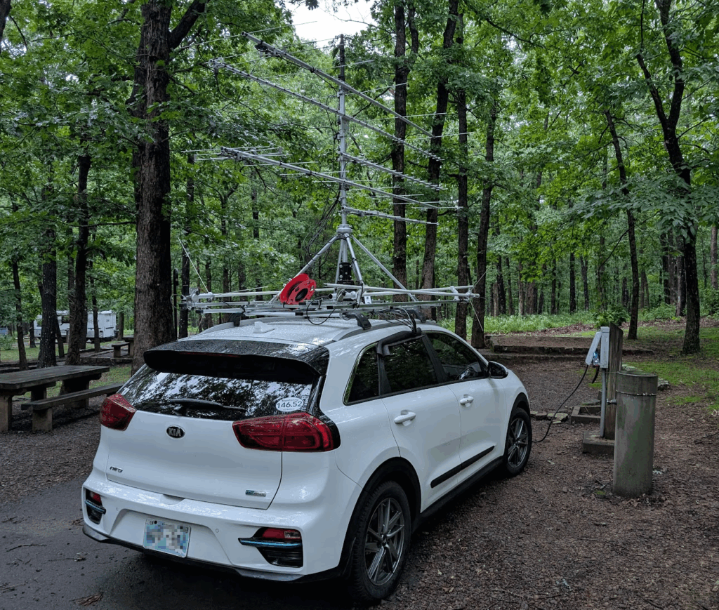
Here you can see the 6m beam, M2 Antennas 6M-3SS, before I mount it during one of the very rare moments of sunshine!
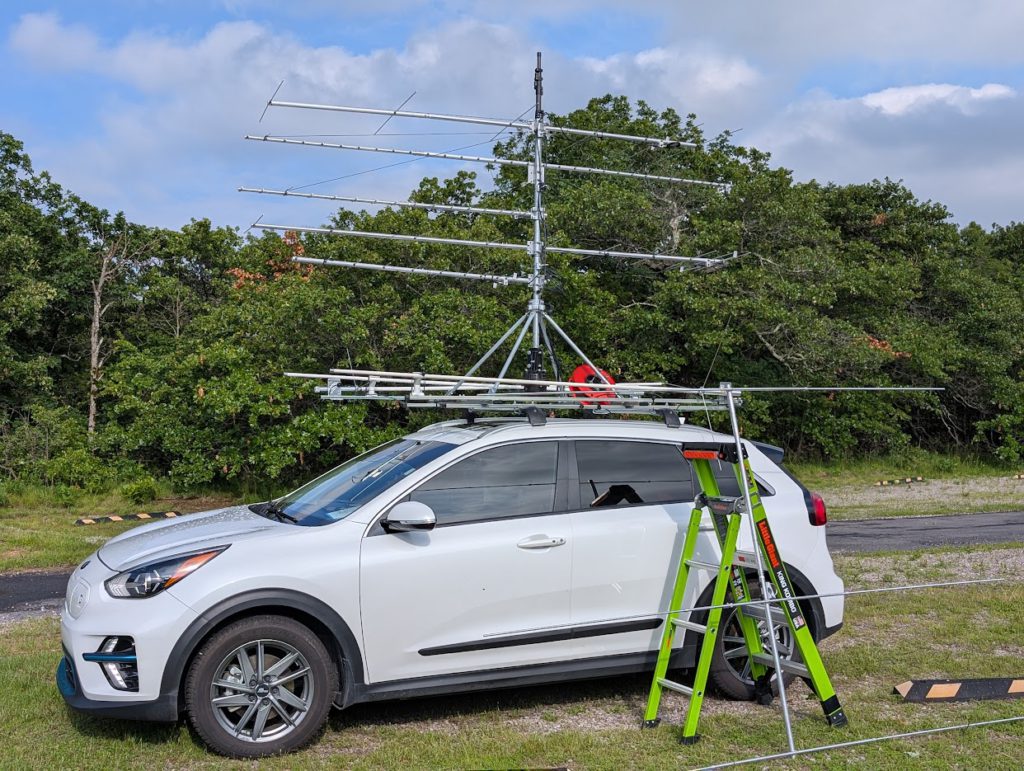
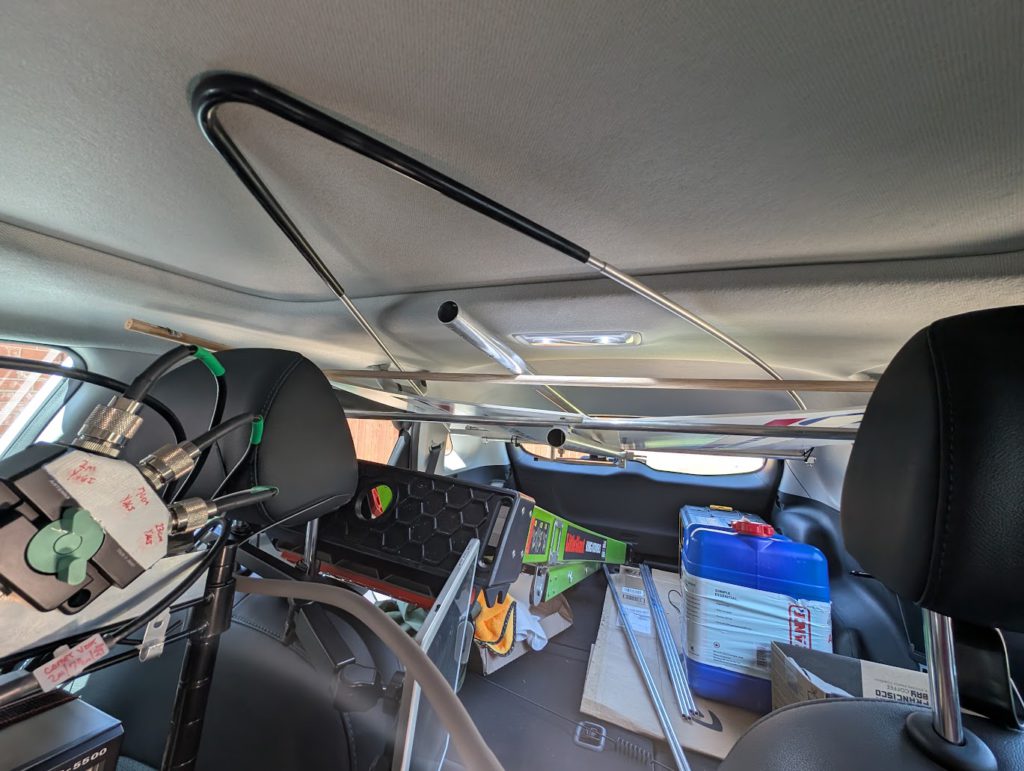
If your wondering, while driving in low-limb areas I would stow both 6m antennas inside the car. I used some hard-wood dowel rods to make a frame that I zip-tied to the handles on the ceiling. I recycled some abandoned political signs to act as a barrier for the ceiling fabric but eventually I was placing everything above it not below it. Here is a photo of the ‘N5ZY/R ceiling storage pocket’ with both the M2 and Par Electronics Omniangle in storage.
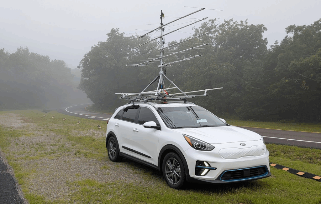
Most of Saturday it was either raining, or fog, or both. The sun did make some appearances but not a lot which was fine since it kept traffic down where I was – I got to have this spot all to myself almost all day. Yes, those are tree leaves stuck in the top of the mast. The wet tree limbs were weighted down and I snagged a few. A few times when the Omni Angle was there it spun around in a “wax on/wax off” move and was unscathed!
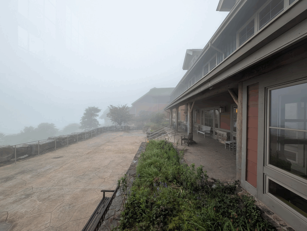
Here is a photo I took from the lodge at breakfast Saturday morning. Visibility was very low but not a problem since I wasn’t there to hike and vacation.
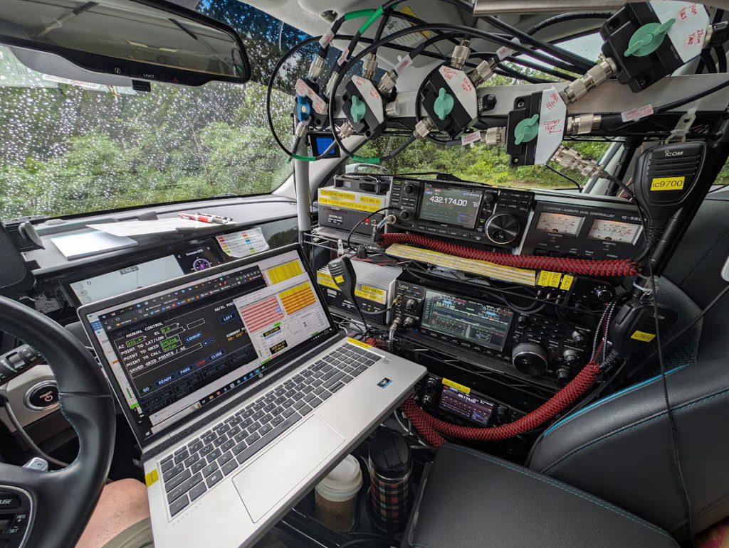
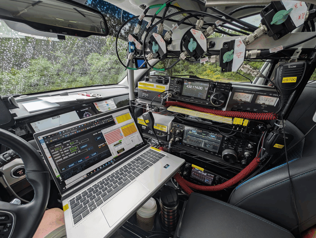
Here is a larger photo from the cockpit. Here you can see that I’m using the S.A.T. controller to point to AA5AM.
First time I’ve car camped. It worked out really. I had a REI self-inflating mattress pad and a pillow to sleep on behind the drivers seat while the car was connected to the 50A split-phase RV power receptacle (how I charge at home). I also plugged-in the 12v LiFePo4 battery charger to the 15A 120v receptacle which gave me some great white noise to sleep to.
Grids I activated while rovering
I spent Saturday on Mount Magazine then Sunday morning I drove out looking for activity in the other planned grids. This story to be continued…
| Grid | QSO Count | Note |
|---|---|---|
| EM25 | 28 | Area between Fort Smith and Fayetteville, after departing Mount Magazine |
| EM26 | 39 | Centennial Park Fayetteville and Turkey Mnt Tulsa |
| EM35 | 184 | Mid-West Arkansas and Mount Magazine |
| EM36 | 0 | Skipped several planned locations in EM36 |
| EM15 | 0 | Sapulpa, OK Comfort Inn Skipped |
| EM16 | 0 | Creek Turnkpike Overlook. Skipped |
Take away
I suspect having this contest on Fathers Day weekend is why I couldn’t find anyone on local repeaters to pull over to Simplex the few times I tried. I had verticals ready but rarely made any contacts on them, but I was so busy on 6m I didn’t have the mental capacity to work 6m DIG and 2m PH simultaneously. I was also too busy to post in Slack to coordinate other bands. I know I left some points on the table and I can improve but I needed more sleep. I was also distracted watching the lightning monitor and weather radar..