Begin: Saturday Jan 18 at 1 PM CDT – During Artic cold front #2!
End: Sunday Jan19 at 10 PM CDT
My call for this contest is N5ZY/R
ARRL January VHF Contest
I was excited to start this contest after making some changes.
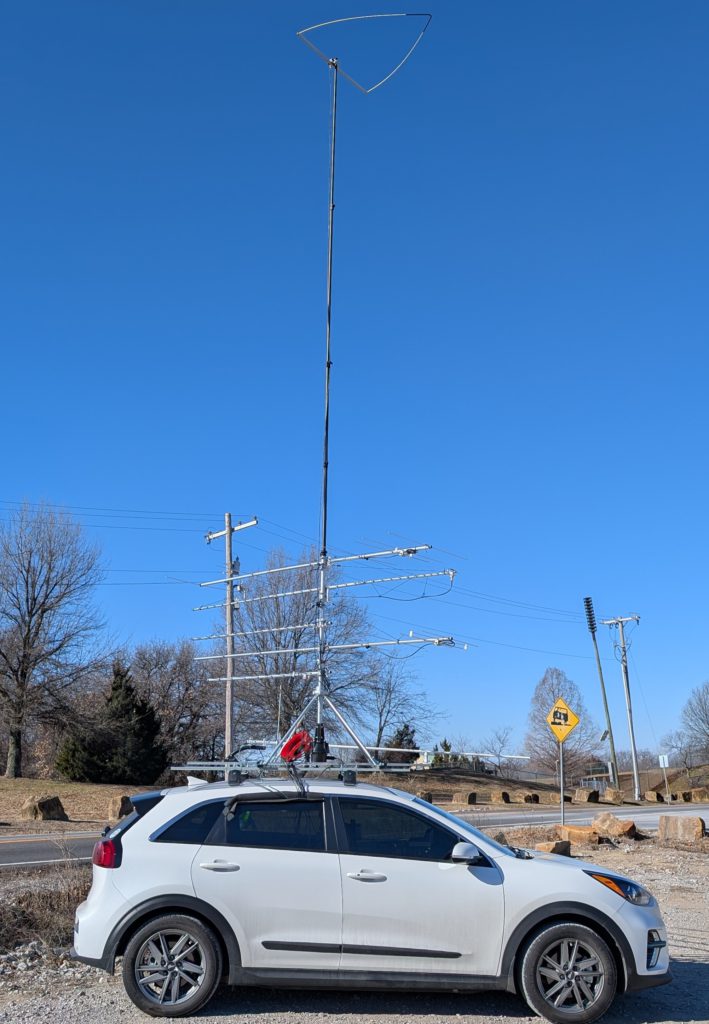
• N0LD suggested a antenna stack re-arrange which I did and things do work with less interference.
• I’ve added 902 MHz
• I’ve replaced the M2 6M loop with Par Electronics 6m Omniangle (more alum and less mast space)
• I’ve replaced all the coax with ABR Industries ABR240-UF. The LMR400Flex was overkill for these short 30 ft runs, it was too heavy and to bulky. The ABR240-UF was perfect! Also the ABR240 would easily roll-up unlike the LMR400-UF which wanted to twist and knot. I appreciate ABR listening to my problems and offering suggestions. Also, even in the 13° F temps it was still flexible.
Goal
I’m about as likely to win this contest as a snowball’s chance in a sauna. My contest strategy is less ‘championship pursuit’ and more ‘scientific curiosity with a side of radio nerdery and fabrication’. My goal isn’t the top of the leaderboard, it’s the top of my learning curve and to have fun, despite the artic cold!
Mission accomplished.
After Contest Summary
I brought along a M2 6m beam however with the artic wind I had no desire to stand atop the car for the time required to remove the 6m loop, replace it with the 6m beam and then attach the elements all while likely watching the ladder blow over. Also in these temperatures is when hardware is dropped by numb fingers and is lost forever. Sunday morning in Tulsa it was 13° F, blowing at 14 mph and I believe the wind chill was 5° F. I don’t know what the wind gusts were but I felt like I needed goggles to keep my eyes from watering on top of the car. It was abnormal!
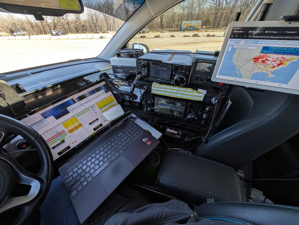
After changing plans a few times as a result of forecasts becoming real I decided to keep it local and interstate adjacent. No driving off into the countryside. Also inside the car I’ve managed to move nearly everything into the passenger seat except the coax switches. I jokingly told my wife “sorry but the ICOM radios called shotgun first”. Actually she does want to go to Mount Magazine with me but the car is full of gear, the ladder, my toolbox, batteries and wires. Despite the name there are lots of wires necessary for wireless communications.
Results
QSOs in Log: 78
Raw Score: 95 Qpts x 27 Mults = 2,565
Lousy. I didn’t make any 222 contacts due to an operator problem, or as I used to say “There’s a short between the steering wheel and the driver seat”. When the “contest brain fog” (or “brain freeze” not fog?) sets in problem solving is hard. Funny enough, the first mistake I made was calling CQ CQ on the Edmond repeater. When I heard the repeater tone I looked at the frequency and thought “why is there a repeater on the simplex freq.” It took me a moment to realize 147.135 is not the simplex freq. I’m out of practice! Also I didn’t find anyone with 900 Mhz gear and only one person had 23cm. Furthermore with the very short daytime in January it didn’t leave a lot of time to make many contacts.
The other experiment (BEV)
I was also experimenting with the car – I’ve never driven the car a few hundred miles when the high temp was 15° F (what idiot would be out driving around in this artic air!). The only issue was charging. The 2020 Kia does not have “winter battery charging pre-conditioning”. That became a thing in the 2nd generation. So on these super cold days at the DC Fast Charger it only charge at about 30 kW/hr which is less than half it’s normal rate. My range of course was effected by the need to run the heater and the huge windcatcher on top of the car, but not as bad as I feared even with the super dense cold air. With “energy = mass x velocity squared” I kept my speed at 65 to 70 mph and my average was 2.1 m/kwH which is bad but considering the windcatcher, heater and lights were on it was better than I thought it might be.
Grids I activated while rovering
I basically spent Saturday in EM16/15 then Sunday I drove to one grid corner in Tulsa, and I spent all morning at one location, EM26. The Jenks/Bixby/Tulsa grid corner is really getting tough. One parking lot has a lot more QRM now due to business development and another favorite find was bulldozed, raised and had foundation forms on it so that spots gone now.
| Grid | QSO Count | Note |
|---|---|---|
| EM15 | 36 | OKC/Tulsa corners |
| EM25 | 5 | Tulsa Grid corner |
| EM16 | 18 | Tulsa Grid corner |
| EM26 | 19 | Tulsa Grid corner |
Endpoints reached
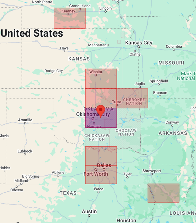
Weird how this map turned out. The January conditions were just all weird. Clearly I needed to get to a location with real elevation like Mount Scott but again the WX made that journey a risk with deadly consequences if something went wrong.
These are the 6m grids I worked wile rovering. This was with the Par Electronics OA-50 Omni Angle. Likely the Stressed Moxon would have been better but I hear many people were struggling for contacts.
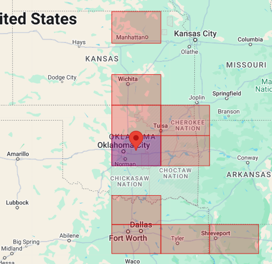
These are the 2m grids I worked. These were using the M2 yagi.
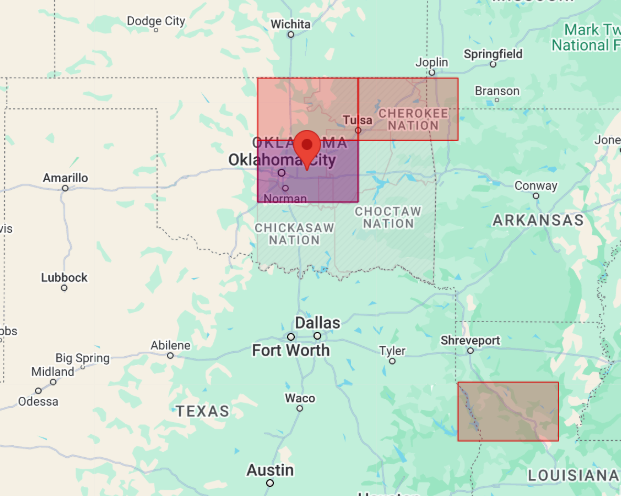
And finally the 70cm grids again using the M2 yagi.
Antennas
| Bands | Antenna |
|---|---|
| Verticals | |
| 2 M | Whip while driving |
| 2/70/23 | Comet Base Vertical CMA-GP-95 while parked only and while the rotor is NOT in use! |
| Horizontals | |
| 6 M | Par Electronics Stressed Moxon, (50.3 Mhz) or M2 Antennas 6M-3SS beam or Par Electronics 6M Omniangle (OA-50) |
| 2 M | M2 Antennas 2M7X (144-148MHz) |
| 1.25 M | M2 Antennas 222-10EZ (222-226 MHz) |
| 70 CM | M2 Antennas 440-11X (420-450 MHz) |
| 33 CM | M2 Antennas 917HD (900-930MHz) |
| 23 CM | M2 Antennas 23CM35 (1250-1300MHz) |
Radios
| Radio | Desc/Use |
|---|---|
| IC9700 | 2m, 70cm and 23 cm USB and FM |
| IC7610 | 6m |
| IC7300 | To use with transverters |
| Q5 Signal L33-28hp50 | Converts 10 M to 33 cm |
| Q5 Signal L222-28hp100 | Converts 10 M to 1.25 M |
| Anytone | VHF Mobile |
Take away
I’ve learned a few things. I’ve also had a few more visions of changes that I want to make for June! Hopefully I will have some time over the next few winter months to implement these changes, practice, and be more prepared for June. I need to move my coax switches to the front so I’m looking at them when changing bands as with ‘Contest Brain Freeze’ I often forgot to change antennas.
I’m going to add a few more vertical antennas and to this this I again need to modify the N5ZY roof rack and add two more coax switches of course.
A big thanks to everyone in the logbook and for those who heard me on the repeater and thought “what the heck, I will QSY to simplex for a minute”. Calling CQ and listening to static on 3 radios just takes the fun away.
The original 2025 January ambitious plan…
18-Jan: Due to an incoming arctic cold front (forecast: high 21°F, low 18°F, wind chill 3°F), I’ve changed plans for safety reasons. The extreme cold poses risks for antenna setup and potential vehicle issues. This plan minimizes exposure to harsh conditions while still participating in the contest. Stay warm and safe, everyone! 73/N5ZY
2025 ARRL Jan VHF Contest (WX Contingency 1)
(Contingency plan 1 was quickly abandoned!)
| Saturday | ||||
|---|---|---|---|---|
| EM16 | 1,072 ft | 36.05729, -97.34344 | Vassar Church | I-35 |
| EM15 | 1,110 ft | 35.72610, -97.41334 | 5251 E Waterloo Rd, Edmond, OK 73034 | OnCue on I-35 |
| Sunday | ||||
| EM26 | 890 ft | 36.07070, -95.99401 | Turkey Mountain upper trailhead | Turkey Mountain |
| EM15 | 700 ft | 35.98606, -96.01076 | 12261 Casper St, Jenks | I-75 W121st St,Jenks/Gpool I-75 (Clarion Hotel right off highway) |
| EM25 | 700 ft | 35.98851, -95.98297 | 11928 S. Mulberry Ct, Jenks | I-75 W121st St,Jenks/Gpool just 1 mile East of Clarion (Curtin Drug)FireDept Adjacent |
| For the row above, the QRM has drastically increased here. I need to find another spot. | ||||
| EM16 | 808 ft | 36.01049, -96.04800 | 4734 W Hilton Rd, Sapulpa | Creek Turnpike Adjacent, little pad of asphalt overlooking hwy. Near I75 |
| I will need to park elsewhere now. This lot is also being developed. | ||||
Note: The text below was contingency plan #1 which was scrapped Saturday morning after observing our WX forecast.
- Saturday: Mount Scott, Oklahoma
– Operating during 6m opening (approx. 4-7 PM)
- Sunday: Turkey Mountain, Tulsa
Operating 9-11 AM (or until propagation ends)
Saturday: EM04, likely EM14 and EM05 and then EM15 on the way home

Sunday Grids: EM26, EM15, EM25 and EM16
